Log in
All resources
Create a design
5,084 Free Artworks of Pages With Maps
piet schipperus
géographie générale; physique, politique et économique (1876)
nouveau cours d'instruction primaire de géographie (1886)
maps from the earth and its inhabitants, vol. iv
the comprehensive history of england (1876)
english-language maps showing history
1870s maps showing history
national library of poland
maps from the earth and its inhabitants, vol. xvii
maps from the earth and its inhabitants, vol. vii
atlas ou representation du monde universel t. 2 (1633)
old maps of nuremberg
women of bosnia and herzegovina by decade
führer durch dalmatien (1899)
maps from the earth and its inhabitants, vol. iv
boston, england
john rocque's 1746 map of london
details of old maps of london
l'abbaye de fontenay et l'architecture cistercienne
maps of fountains abbey
19th-century maps of senegal
orientalist painting
maps from the earth and its inhabitants, vol. xvii
archaeological sites in ohio
maps from the earth and its inhabitants, vol. v
charles eugène perron
maps from the earth and its inhabitants, vol. vii
yarlung tsangpo
maps from the earth and its inhabitants, vol. viii
british raj
old maps of lake titicaca
maps of lake titicaca
the comprehensive history of england (1876)
english-language maps showing history
the comprehensive history of england (1876)
english-language maps showing history
the comprehensive history of england (1876)
english-language maps showing history
the comprehensive history of england (1876)
danube in 1704
maps from the earth and its inhabitants, vol. ix
darah nur
maps from the earth and its inhabitants, vol. vi
alay district
the comprehensive history of england (1876)
english-language maps showing history
maps of the west indies federation
1810s maps of the caribbean
physical geography (1899) by davis
1899 maps of oregon
géographie générale; physique, politique et économique (1876)
19th-century maps of borneo
géographie générale; physique, politique et économique (1876)
19th-century maps of the nile river
géographie générale; physique, politique et économique (1876)
1876 maps of italy
nouveau cours d'instruction primaire de géographie (1886)
1886 maps of europe
physical geography (1899) by davis
1899 maps of pennsylvania
a system of modern geography (1810)
1810 maps of germany
old maps of dublin
dublin bay
old hemisphere world maps (partner files)
arnold's geographical handbook (1899)
a school geography (1898) by bird
old maps of french polynesia
women of the world from the british library mechanical curator collection
ainu people in art
1710s maps of the world
maps by edward wright
nouveau cours d'instruction primaire de géographie (1886)
19th-century maps of guadeloupe
nouveau cours d'instruction primaire de géographie (1886)
19th-century maps of martinique
physical geography (1899) by davis
1899 maps of oregon
géographie générale; physique, politique et économique (1876)
hydrographic maps of argentina
géographie générale; physique, politique et économique (1876)
old maps of rivers of france
géographie générale; physique, politique et économique (1876)
1870s maps of australia
maps of the rocky mountains
1810s maps of canada
géographie générale; physique, politique et économique (1876)
19th-century maps of java
nouvelle géographie universelle, vol. v
maps of orenburg oblast
géographie générale; physique, politique et économique (1876)
1876 maps of turkey
géographie générale; physique, politique et économique (1876)
1870s maps of the atlantic ocean
nouveau cours d'instruction primaire de géographie (1886)
topographic maps of france
nouveau cours d'instruction primaire de géographie (1886)
economic maps of france
géographie générale; physique, politique et économique (1876)
1870s maps of austria
maps of the seine river
1886 maps of france
géographie générale; physique, politique et économique (1876)
19th-century maps of pomerania
19th-century maps of cornwall
19th-century maps of devon
géographie générale; physique, politique et économique (1876)
18th-century maps of alpes-maritimes
a school geography (1898) by bird
cork harbour
old maps of haarlem
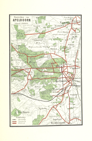
piet schipperus
maps of apeldoorn
piet schipperus
old maps of alkmaar
piet schipperus
old maps of nijmegen
piet schipperus
nouveau cours d'instruction primaire de géographie (1886)
maps of the colonies of france
nouveau cours d'instruction primaire de géographie (1886)
old maps of french guiana
nouveau cours d'instruction primaire de géographie (1886)
old maps of réunion
nouveau cours d'instruction primaire de géographie (1886)
old maps of new caledonia
maps of utrechtse heuvelrug
piet schipperus
maps of gaasterland
piet schipperus
maps of breda, netherlands
piet schipperus
ghosts & ghoulish scenes
old maps of gelderland
piet schipperus
maps of het gooi
piet schipperus
old maps of twente
piet schipperus
old maps of gelderland
piet schipperus
old maps of doetinchem
piet schipperus
old maps of amersfoort
piet schipperus
atlas minor gerardi mercatoris (1609)
maps of asia by mercator-hondius
album der chemnitz-annaberger staats-eisenbahn (1866)
rail transport maps of saxony
shadows of the east; or, slight sketches of scenery, persons and customs, from observations during a tour in 1853 and 1854, in egypt, palestine, syria, turkey, and greece (1855) by tobin
maps of upper egypt
shadows of the east; or, slight sketches of scenery, persons and customs, from observations during a tour in 1853 and 1854, in egypt, palestine, syria, turkey, and greece (1855) by tobin
1850s maps of palestine
old maps of the county of ravensberg
burg limberg
maps from the earth and its inhabitants, vol. xiii
old maps of zanzibar
maps from the earth and its inhabitants, vol. xiv
old maps of manila
maps from the earth and its inhabitants, vol. xiv
maps of hawaii island
maps from the earth and its inhabitants, vol. iv
1870s maps of scotland
maps from the earth and its inhabitants, vol. xvi
19th-century maps of havana
maps from the earth and its inhabitants, vol. ix
religion maps of asia
maps from the earth and its inhabitants, vol. iv
19th-century maps of warwickshire
maps from the earth and its inhabitants, vol. xv
maps of the gulf stream
maps from the earth and its inhabitants, vol. iv
maps of the north atlantic
maps from the earth and its inhabitants, vol. vii
old maps of beijing
maps from the earth and its inhabitants, vol. xviii
maps of the indigenous peoples of south america
maps from the earth and its inhabitants, vol. iv
old maps of manchester and salford
maps from the earth and its inhabitants, vol. xvii
maps of native american tribal territories
maps from the earth and its inhabitants, vol. xvi
maps of the yucatan peninsula
maps from the earth and its inhabitants, vol. viii
old maps of kolkata
maps from the earth and its inhabitants, vol. xvii
old maps of the mississippi delta
maps from the earth and its inhabitants, vol. vii
maps of weather and climate of china
maps from the earth and its inhabitants, vol. xiv
old maps of mauritius
maps from the earth and its inhabitants, vol. xv
maps of niagara falls, new york
maps from the earth and its inhabitants, vol. iii
old maps of trieste
maps from the earth and its inhabitants, vol. iv
maps of loch lomond
maps from the earth and its inhabitants, vol. xii
old maps of the canary islands
maps from the earth and its inhabitants, vol. xii
old maps of bioko
maps from the earth and its inhabitants, vol. iv
old maps of norwich
maps from the earth and its inhabitants, vol. xi
1870s maps of morocco
maps from the earth and its inhabitants, vol. vi
religion maps of asia
maps from the earth and its inhabitants, vol. xiii
maps of port elizabeth
801 - 900 of 5,084
Next page
/ 51

![Gerardi Mercatoris and I. Hondii Atlas or Representation of the Universal World, and of the Parts of It, Made in Tables and Very Ample Descriptions. [t. 2].](https://cdn.creazilla.com/illustrations/10001133003/gerardi-mercatoris-and-i-hondii-atlas-or-representation-of-the-universal-world-and-of-the-parts-of-it-made-in-tables-and-very-ample-descriptions-t-2-sm.webp)